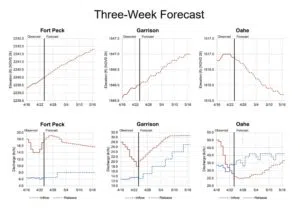
Yesterday’s (Wed.) three-week projection for the Missouri River Mainstem System of dams puts all reservoir levels below their exclusive flood control pool elevations. But, in reality, the level at Lake Oahe has risen slightly putting it back into the exclusive zone.
Chief of the Corps’ Missouri River Basin Water Management Division John Remus says due to plains snow melt in the tributary basins that empty into the Fort Randall, Big Bend and Oahe reservoirs, the pool elevations at those projects increased significantly. He says they’re maintaining releases higher than inflows at the Oahe and Fort Randall Dams to gain more flood control storage space in those reservoirs.
The exclusive flood control space at the Oahe reservoir is from 1617-1620 feet. The water level is currently at 1617.1. Inflows at Oahe are 26,000 cfs while releases are 34,000 cfs.
Releases from Fort Peck and Garrison will begin to step up as the mountain snowpack begins to melt. Gavins Point releases are forecast to remain steady at 55,000 cfs to continue evacuating runoff from the spring plains snowmelt stored in the mid-system projects.
River stage forecasts are issued by the National Weather Service’s Missouri Basin River Forecast Center and updated daily at www.weather.gov/mbrfc.
Missouri River Basin daily update: http://www.nwd-mr.usace.army.mil/rcc/reports/pdfs/weeklyupdate.pdf
All US Army Corps managed dams–reservoir levels, inflows and releases: http://www.nwd-mr.usace.army.mil/rcc/reports/pdfs/MRBWM_River_Daily.pdf


