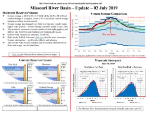
Much-above average runoff in the upper Missouri River basin (above Sioux City, Iowa) extended into June following widespread, heavy rainfall in South Dakota.
The US Army Corps of Engineers says runoff in the upper basin last month was 8.7 million acre feet, which is 159 percent of average. Runoff remained particularly high in the Fort Randall to Gavins Point and Gavins Point to Sioux City reaches, which were three and four times average, respectively.
Despite the heavy rainfall, the Oahe Dam reservoir went down 2.2 feet during June.
Reservoir Forecasts:
◾Big Bend Dam
- ◦Average releases past month – 45,700 cfs
- ◦Forecast average release rate – 54,200 cfs
- ◦Forecast reservoir level – 1420.0 feet
◾Oahe Dam
- ◦Average releases past month – 49,900 cfs
- ◦Forecast average release rate – 54,600 cfs
- ◦End-of-June reservoir level – 1616.6 feet (falling 2.2 feet during June)
- ◦Forecast end-of-July reservoir level – 1615.5 feet
Additional precipitation, lack of precipitation or other circumstances could cause adjustments to the reservoir release rates.
The 2019 upper basin runoff forecast is 49.9 million acre-feet. If realized, this runoff total would be the second highest runoff in 121 years of record-keeping, only surpassed by 2011 (61.0 MAF) and exceeding the 49.0 MAF observed in 1997. Upper basin runoff in 2018 was 42.1 MAF, which is currently third highest.
Updates on basin conditions, reservoir levels and other topics can be viewed here: http://www.nwd-mr.usace.army.mil/rcc/reports/pdfs/weeklyupdate.pdf.
To view the detailed three-week release forecast for the mainstem dams, go to http://www.nwd-mr.usace.army.mil/rcc/reports/twregfcast.pdf.
The Corps has established webpage at go.usa.gov/xE6fC (the URL is case sensitive) that can be saved to your mobile phone’s home screen which provides links to the most up-to-date information from the U.S. Army Corps of Engineers including runoff and release schedules, links to the Omaha and Kansas City Districts, links to Corps social media accounts and provides a link to the National Weather Service, Missouri Basin River Forecast Center.


