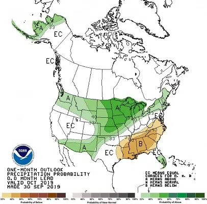
The chances of a wet October increased with the latest climate outlook update, released on September 30, 2019.
SDSU Extension State Climatologist Laura Edwards says in the first few days of the month, rain or snow has scattered across much of the state. There hasn’t been a heavy rain or snow event this month. The outlook shows odds leaning towards much of the same pattern in the weeks ahead.
It is possible that mid-month may bring a period of dry weather, but then a wetter pattern is projected to return by the end of October. This on-and-off wet pattern will maintain the high levels of soil moisture and surface water in lakes, stock ponds and rivers. As a result, high runoff is expected to continue from South Dakota tributaries into the Missouri River.
River Forecast:
On October 1, the US Army Corps of Engineers updated their forecast for total runoff this calendar year for the Missouri River basin. The Upper Missouri basin, comprised of all rivers and tributaries that feed into the Missouri River above Sioux City, IA, will likely have near record runoff by the end of December. The current forecast is for 61.0 million acre-feet of water to pass through Sioux City, IA. This would match the total runoff in 2011, the current highest year in 121 years of record. The Missouri River at this point is already the second highest runoff year on record, with nearly three months to go in the year.
In the month of September, the runoff from the Eastern South Dakota into the Missouri River was sixteen times the long-term average, and more than twice the previous record. Overall runoff in the basin into the mainstem Missouri River above Sioux City was twice the previous record for the month, which was recorded in 1986.
Agricultural Impacts:
The current wet conditions and outlook for October present challenges for our state’s corn and soybean farmers. A killing frost/freeze in Western and Northern South Dakota in the first week of October did put an end to the growing season in those regions. Some Central and Southeastern areas will likely have a frost date later than average, but the high moisture conditions will prevent or slow down fall harvest. High moisture in both soils and grain for harvest will delay many farmers, in addition to the extra time needed for much of our late-planted corn crop to reach maturity.
The relatively dry period in late September did allow rapid progress in winter wheat planting, especially in central South Dakota. Some moisture now would help this new crop emerge and become established as we avoid freezing temperatures for a little while longer.
Across the state high moisture conditions will continue to plague hay production, but corn silage cutting is still ongoing in early October.


