Redistricting Recap by District 24 Senator Mary Duvall (Nov. 12, 2021).
Legislators wrapped up its decennial redistricting work on Wednesday afternoon (Nov. 10, 2021), adopting a final map showing new legislative districts based on the 2020 census. The map is the result of compromise among legislators from both chambers who recognized that our current legislative districts need to change to match changes in South Dakota’s population. While many legislators would have preferred to keep their current legislative boundaries, most were willing to set aside their personal preferences and work together to develop new legislative boundaries that fit all of South Dakota.
We understand that in dividing up the state, you can’t make everybody happy. We were warned of that reality early on.
Serving 886,667 people is an interesting challenge. We held many public hearings, with an extremely small percentage of South Dakotans commenting at those hearings. One criticism was that the map doesn’t incorporate all the diverse opinions we heard at the public listening sessions. Given that some comments conflicted with one another, it was impossible to satisfy every concern. One of the most common themes we heard during from the public was “keep my county whole.” As we weighed popular sentiment against our Constitutional obligation of one person, one vote, it became obvious that not all wishes from the public could be met. In working to develop the map, we tried to avoid splitting counties, and tried to protect communities of interest, all while achieving the right population size for each district.
The new map takes effect for next year’s election cycle. It has 35 Senate districts, ranging in population size from 23,354 to 26,600. This is slightly above the 10 percent total population deviation that is often presumed to be constitutional. Districts 26 and 27 have slightly smaller population numbers than the others. These districts include reservation lands, where we worked to add as much population as we could without diluting the minority population’s voting strength, to comply with the federal Voting Rights Act.
I believe the final map will serve our state well for the next ten years. The redistricting process is about developing logical district lines for the citizens of our state. Ultimately, I believe it is important for all legislators to work across district lines for policies that are good for all of South Dakota.
South Dakota legislative district boundaries based on 2020 US Census data.
Image credit South Dakota Legislative Research Council website.
Revised Senate “Blackbird” proposed legislative districts map by District 24 Senator Mary Duvall (Oct. 25, 2021).
“The Senate Legislative Redistricting Committee, on a 5-2 vote, is recommending the “Blackbird 2.0” map proposal for the full Senate to consider when it convenes for a special legislative session on redistricting in November. The new version of the map reflects changes to the original Blackbird map based on public feedback, conversations with House colleagues, and ideas offered in other maps.
“Legislative redistricting has been called perilous work. It is a process that will not make everyone happy. Our Senate proposal reflects a commitment to coming up with a map that is fair for South Dakota, based on census data to develop districts that are as nearly equal in population as is practicable, that are contiguous and compact, and that respect political boundaries and communities of interest.
“Under the new map, areas of Hughes and Hyde counties that are part of the Crow Creek Indian Reservation would be included with the rest of the reservation in District 26. An earlier version of our map kept Hughes and Hyde counties whole but included part of Tripp County to help meet population goals in District 26. The new map keeps all of Tripp County in District 21.
“We changed the map to keep Fall River County whole, rather moving some of the eastern precincts to District 27. We propose adding part of eastern Pennington County to District 27 to get us closer to our population goals while at the same time adhering to the Voting Rights Act.
“Based on public input and feedback from House members, we revised the map to put all of Turner County, except for one precinct needed to meet population requirements in the neighboring district, into a district with southern Lincoln and part of Union to form a rural district south of the Sioux Falls metro area. We propose keeping Clay County whole with the exception of one precinct needed to meet population needs in Yankton County. We revised the map to keep the entire city of Watertown within one legislative district, aligning the rest of Codington County with Grant, Deuel, Hamlin, and Clark counties to comprise a rural legislative district.
“We received many comments about the very southeastern part of South Dakota, encompassing Clay and Union Counties. Much of the public feedback expressed concern about splitting the town of Vermillion among three different legislative districts. Our proposal puts Clay and southern Union County back together, as they were in the 1970s and 1980s, and keeps Vermillion in one district.
“Brown County residents expressed a desire to be split between no more than two legislative districts. As we looked at map proposals based on this request, the results showed the adjoining legislative District 23 stretching from Pollock to Wessington Springs, splitting Beadle County along the way. Our new map proposes adding part of rural Brown County to District 23, to meet population requirements.
“The Sioux Falls area generated mixed comments from the public. One thing we heard early in the process is that the current Districts 9 and 25 look “gerrymandered.” We are proposing a map that joins the agricultural area of northern Minnehaha County with Moody County, while the area encompassing Brandon and the growth in eastern Sioux Falls would have its own legislative district. We also propose that District 9 encompass northwest Sioux Falls and the immediate townships surrounding Sioux Falls where the city is expected to see rapid growth.
“Our revised “Blackbird 2.0” map is available for viewing online at sdlegislature.gov under the 2021 Redistricting tab. If you have questions or comments, please feel free to reach out to any member of the Senate redistricting committee.”

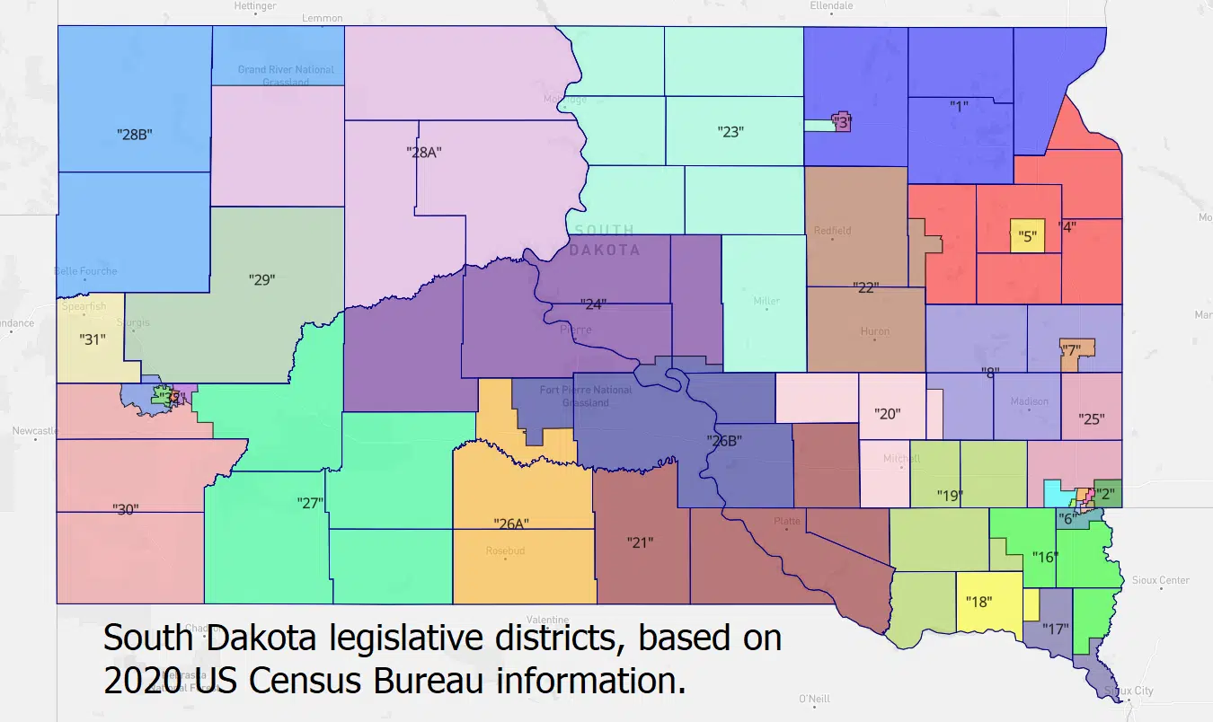
South Dakota Senate Redistricting Committee Blackbird 2.0 revised map proposal.
Image credit SD Legislative Research Council.
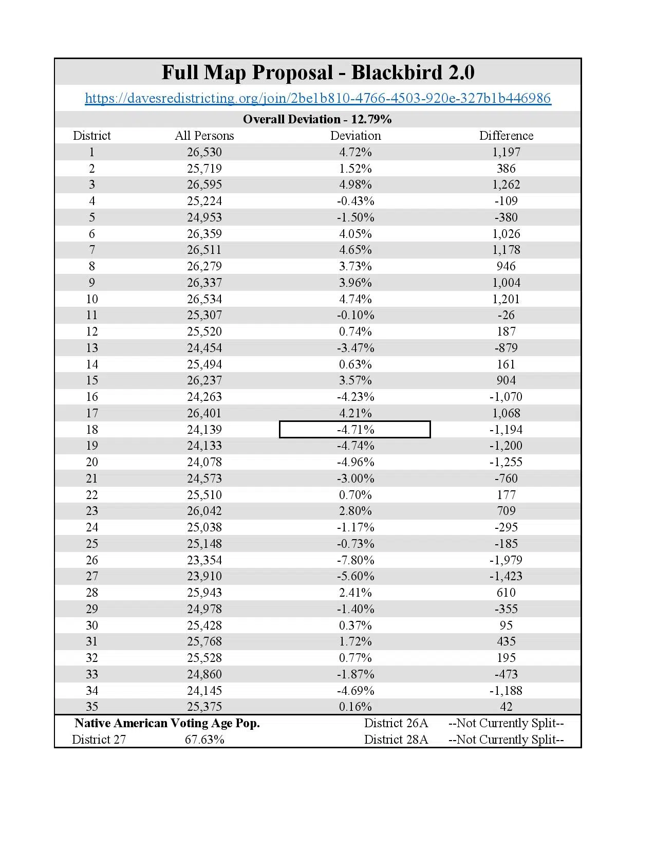
South Dakota Senate Redistricting Committee Blackbird 2.0 revised map proposal statistics.
Image credit SD Legislative Research Council.
Creating updated legislative districts for South Dakota by District 24 Senator Mary Duvall (Oct. 15, 2021).
The House and Senate Legislative Redistricting Committees spent three days traveling across South Dakota to take public input on what the state’s new legislative districts should look like. We started at 8:00 a.m. on Oct. 11, 2021, in Rapid City and ended at 8:30 p.m. on Oct. 13, 2021, in Sioux Falls. We traveled over 1,100 miles, making stops in Mission, Mobridge, Aberdeen, and Watertown along the way. More than 200 people attended our listening sessions. We heard from about 100 people who took time to weigh in on South Dakota’s future legislative districts.
Several key themes emerged from public comments:
Many people indicated they generally like their current legislative districts. As we move forward, we are trying to preserve the core of the current districts as much as possible. Because of changes in South Dakota’s population – an increase of about nine percent over the past ten years, primarily in the southeast part of the state – we know that at least 34 of the state’s 35 legislative districts will need to change to comply with our constitutional requirement of one person, one vote. The only district that doesn’t need any alteration is the one encompassing Lawrence County, which grew at the right pace to comprise a legislative district.
Voters and county auditors would like counties to be left whole where possible. According to the census, seven of our state’s 66 counties are too large to fit within one legislative district. Brookings, Brown, Codington, Lincoln, Meade, Minnehaha, and Pennington counties will have to be split into more than one district, to satisfy the constitution’s equal protection clause. As we work to assign the rest of the state into logical legislative districts, we are trying to minimize splitting any of the remaining counties as much as possible.
There were many comments about keeping urban districts as urban as possible, and rural districts as rural as possible, particularly near Sioux Falls. The U.S. Census Bureau defines an urban area as 2,500 residents or more. As the Senate looks at growth patterns along the I-29 corridor, we are working to keep the urban districts as compact as possible, and the rural districts as rural as possible.
We heard from the Native American community about protecting minority voting rights. One of the ways our committee is addressing this is to follow the current boundaries for Districts 26, 27, and 28 as much as possible to meet the requirements of the Federal Voting Rights Act, while also meeting population requirements as required by the Constitution.
Protecting communities of interest is another theme that emerged from our listening sessions. While this concept is not clearly defined in law, we heard how citizens see their local community of interest. As our state becomes more diverse, we expect this conversation to continue.
Over the next few weeks we will be working to incorporate these suggestions into a proposal for legislators to consider during the Special Session on Redistricting, set for November 8-9, 2021, in Pierre. Our over-arching goal is to develop a map that meets our constitutional obligations and statutory guidance, and is fair for the residents of our state.
Proposed maps are available for the public to view at sdlegislature.gov. Additional thoughts and ideas can be emailed to sdredistricting@sdlegislature.gov.


Comments