The latest National Oceanic and Atmospheric Administration climate outlook shows the dry conditions in South Dakota won’t improve in the next few months.
SDSU Extension State Climatologist Laura Edwards says the most recent US Drought Monitor map (Jan. 21) shows over 60% of the state in Moderate (D1) to Extreme (D3) drought categories. She says the remaining nearly 40% is in the Abnormally Dry (D0) category. Three months ago, only 42% of the state was in the Moderate to Extreme drought categories
Edwards says lack of precipitation recently has made a dry situation worse, as soil and surface water are also evaporating during this abnormally warm winter. She says the lack of snow cover is not able to protect winter wheat from possible frost damage, should areas see extreme cold temperatures.
Last week, the NOAA Climate Prediction Center released its February outlook as well as its three-month outlook through April. Edwards says the temperature expectations for South Dakota in February start with a bit of uncertainty because the current computer models are showing some fluctuations between a colder and warmer than average for the start of the month ahead. She says for the three-month period of February through April, odds start to lean towards warmer than average temperatures for all but the far northwest corner of South Dakota.
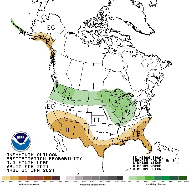
The precipitation outlook for the state shows February slightly more likely to have wetter than average conditions for all parts of the state but the far southern tier along the Nebraska border. Edwards says to get any substantial relief from drought conditions, spring precipitation will be more important than ever this year.
“Many areas of the state were four or more inches below average precipitation in 2020,” Edwards says. “The winter warmth is allowing for more moisture loss when it is often ‘locked’ in as frozen soils and waterways.”
As a result of the dry period from late summer through January, nearly everywhere in the state is carrying a shortage of soil moisture to start the 2021 growing season for grasses, pastures, row crops, gardens and trees. Edwards says while winter precipitation can help in improving drought conditions, it can also run off frozen ground instead of infiltrating into the soil.
In addition to a dry winter, La Niña conditions — driven by colder waters in the Pacific Ocean near the equator by South America — are in place this season. These conditions often can change the jet stream patterns over North America. For South Dakota, past La Niña winter seasons have brought colder than average temperatures, but Edwards says that has not been the case this year.
“Since 1950, there have been just four La Niña winters with warmer than average temperatures in our region, the most recent being 2011-2012,” Edwards says.
Finally, Edwards says there is another factor at play this year — the Arctic Oscillation over the northern latitudes around the North Pole.
“That has been more prominent over our region in preventing colder air from moving south into the Dakotas,” Edwards says. “Many climate forecasters see the Arctic Oscillation in its current phase weakening, and thus allowing more cold air to come into the northern US states, as is shown in Montana and North Dakota’s outlooks this month.”

The NOAA Climate Prediction Center’s February precipitation outlook shows slightly wetter than average conditions for most of the state except the far southern tier along the Nebraska border.
Image credit NOAA.


Comments