June 2025:
South Dakota Grassland Productivity Map conditions have changed across the state since last updated on June 1, 2025. These maps, produced through the SD Natural Resources Conservation Service Drought Tool, will be updated only one more time, reporting conditions as of July 1.
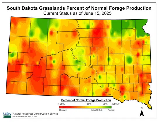
The “current status” map compares precipitation we have received to the average precipitation from the last two years. May and June have brought SD a much-needed drink of water across the state and conditions have improved greatly.
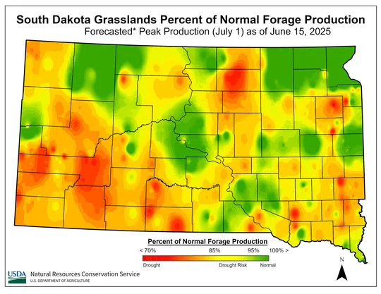
The “forecasted” map shows what peak forage production is predicted to look like if the remaining time between now and July 1 has average rainfall. As we get closer to July 1, we are less likely to catch up to “normal” in certain areas of the state.
Some parts of the state have been brought back to normal conditions, while others are still having a precipitation deficit compared to normal. Future moisture may set warm season forages up for success, however, most of our cool season forages are nearly done producing for the year. Consider speeding up your rotations or accessing alternative forages to give cool season-dominated pastures a rest if they are not looking good. Use the SD Grazing Exchange to see if there are any alternative forages (cover crops) available in your area!
For more information about Grassland events in your area, visit the SD Grassland Initiative’s Calendar of Events, where events for learners of all ages are posted.
USDA NRCS current drought condition map as of June 15, 2025.
Courtesy image.
USDA NRCS FORECAST drought condition map as of June 15, 2025.
Courtesy image.
The following resources are also available:
- SD NRCS Range and Pasture page: bit.ly/Range_Pasture
- South Dakota Grassland Coalition Drought Planning website: sddroughtplan.org/
- National Drought Mitigation Center: drought.unl.edu/ranchplan/Monitor.aspx
- National Integrated Drought Information System: drought.gov/
- U.S. Drought Monitor: droughtmonitor.unl.edu
- South Dakota State University Extension Drought Resources: extension.sdstate.edu/drought
- SD Growing Resilience Web page: www.growingresiliencesd.com
- SD Grazing Exchange: www.sdgrazingexchange.com
April 2025:
South Dakota (SD) grasslands continue to face dry conditions as illustrated in the mid-April SD Grassland Productivity Map on the SD Natural Resources Conservation Service (NRCS) website under Range and Pasture. As a product of the SD Drought Tool, these maps utilize a two-year weighted average of precipitation data to determine a percent of normal production calculation incorporating historical clipping data from across the state.
State rangeland specialist, Emily Rohrer, shared that forage maps relate to grassland forage production and not cropland as the maps will not predict forage quality. Producers utilizing this tool should consider local conditions when making decisions as a dry fall and even drier winter have set much of the state up for dry conditions going into the spring, however, the most significant months for precipitation in our region are April, May and June.
What can a producer do? State Conservationist, Tony Sunseri states, “Rainfall cannot be controlled, but being proactive and creating a drought plan is controllable. Visit the SD NRCS webpage to locate online tools and an office nearest you.” When planning, consider management adjustments to your grazing operation, review which pastures you grazed last year, and consider alternating start times which give native plants differing rest periods to help build resiliency. Combining herds and speeding up rotation through pastures to give additional rest time for forage plants during the growing season is beneficial as well.
For additional recommendations, visit with a local NRCS conservationist, South Dakota State University extension specialist, or consider asking a mentor through the SD Soil Health Coalition’s mentoring app Growing Connections or seek out the SD Grassland Coalition’s mentoring network.
The following resources are also available:
- SD NRCS Range and Drought page: bit.ly/Range_Pasture
- South Dakota Grassland Coalition Drought Planning website: sddroughtplan.org/
- National Drought Mitigation Center: drought.unl.edu/ranchplan/Monitor.aspx
- National Integrated Drought Information System: drought.gov/
- U.S. Drought Monitor: droughtmonitor.unl.edu
- South Dakota State University Extension Drought Resources: extension.sdstate.edu/drought
- SD Growing Resilience Web page: www.growingresiliencesd.com
- SD Grazing Exchange: www.sdgrazingexchange.com/
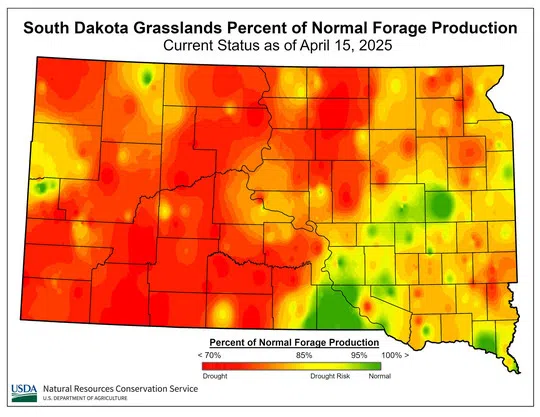
USDA NRCS current drought condition map as of April 15, 2025.
Courtesy image.
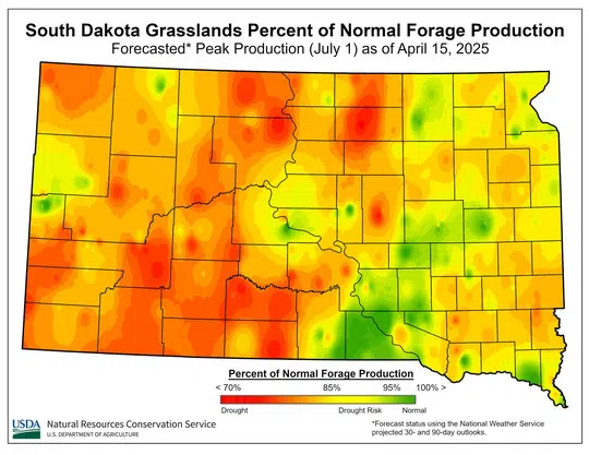
USDA NRCS FORECASTED drought condition map as of April 15, 2025.
Courtesy image.
Forecast Drought Condition Map-April 15, 2025.


Comments