The South Dakota State Historical Society Museum will hold this month’s Family Fun Saturday event tomorrow (Aug. 7) from 10am-2pm (9am-1pm MDT), but it won’t be at the Cultural Heritage Center.
This month’s activity will be held at the Capitol Lake Visitors Center in Pierre. It is free and open to the public.
Visitors will explore three ways of measuring South Dakota using hands-on materials. The program will be held outdoors, and hand sanitizer will be available at all stations. Information about historic individuals related to each activity will be available at the hands-on stations as well.
One of the tools Lewis and Clark used to gather information for their maps was the sextant. This tool let them determine distances and heights of faraway objects. Program visitors will use a sextant to determine the distance to nearby objects.
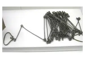
Surveying crews in Dakota Territory measured the land using a Gunter’s chain. Gunter’s chains, named after their inventor, Edmund Gunter, are 100 links long and measure 66 linear feet. “Chaining” meant stretching the chain out straight, marking its end point and gathering the chain up. Visitors will use a 50-link reproduction chain to measure distance like the early surveyors in Dakota Territory.
Joseph Nicollet, a 19th-century French geographer and mapmaker, mapped the Upper Mississippi River basin, including what would become South Dakota. His maps were the most accurate at the time. Nicollet was the first mapmaker to use “hachuring” – hash marks – to show elevation or differences in land height. On Aug. 7 visitors can build their own carpet “mountain” and draw a contour map using Nicollet’s hachuring technique.

A Gunter’s chain is on exhibit in the museum at the Cultural Heritage Center in Pierre.
(Photo courtesy South Dakota State Historical Society)


Comments